timistravels

My job allows me to visit a lot of Alaska on a yearly basis. I wanted to capture the trips in one location!

Chevak, Alaska; pull out a map!

March 22-25, 2016

When doing superintendent searches I get to go to a lot of great places, and this adventure lead me to Chevak. I flew from Juneau to Anchorage and Anchorage to Bethel on an Alaska Air jet then took a smaller airline (Grant Air) to Chevak. Chevak is located on the north bank of the Niglikfak River, 17 miles east of Hooper Bay in the Yukon-Kuskokwim Delta. Chevak is a Cup’ik Alaska Native village. The original tribe is the Qissunamiut Tribe. Commercial fishing and subsistence activities are an important part of the local culture. The community is not on the road system. The landscape consists of flat tundra and there are no trees, hence when it snows there are a lot of drifts and whipping wind! However, the river and rolling hills create a beautiful village and there are mountains with trees in the distance.

Alaska Native Cup’ik’s have inhabited the region for thousands of years. Chevak is also known as New Chevak because residents inhabited another village called Chevak before 1950. “Old” Chevak, on the north bank of the Kiuqllivik River, 9 miles east of Hooper Bay, was abandoned because of flooding from high storm tides. The name Chevak refers to “a connecting slough,” on which “Old” Chevak was situated. Chevak is one of two remaining Cup’ik communities.

Fish, seal, beluga, walrus, clams, waterfowl, editable plants and berries are harvested in this maritime climate. Temperatures range from -20º (with windchill) to 79ºF, while we were there it was 23 with windchill down in the single digits.  Snowfall averages 20 inches per year. Freeze-up occurs at the end of October; breakup occurs in May or June.

I have to say the Cup’ik people are very friendly and proud of their local traditions and culture, and Chevak is said to be the friendlies village in Alaska. There are a lot of snowmobiles/snow machines AND 4 runners in town, but very few full sized vehicles.  It is a dry village and the sale, importation or distribution of alcohol is banned in the village.

IMG_8118

Enter a caption

IMG_8111

taking advantage of the strong winds that blow through Chevak.

IMG_8096

School District Logo

IMG_8097IMG_8098

IMG_8094

Enter a caption

IMG_8122

kids are so happy and loving!

IMG_8085

The Pledge of Allegiance in Cup’ik

IMG_8080

When you enter the school there are cabinets full of traditional art!  Aren’t these beautiful?

1 Comment »

Viñales, Cuba; My favorite part of the country

Dec. 22-25

Viñales, Cuba

For 35 CUC’s /pp we took a personal taxi to Viñales. Our driver Pepe brought his 8 year old son John Anthony with him as they were on vacation from school. It was a delightful ride and John Anthony sang “happy birthday” to me J. His English was about as good as my Spanish so instead of ‘birthday’ he said ‘baby’ which made me laugh even more!

The ride was 70% along a highway but what stood out most were all the people along the highway either 1) waiting for a bus or such or 2) holding out money hoping that a taxi might stop and pick them up. Something you’d never see in the states! There were also a number of horse drawn buggies along the roadway as well… as we learned to say “only in Cuba”.

The last 15 miles were off the highway and took us towards the community of Viñales. The landscape was rolling and green. All of the Cuban we met constantly said that Viñales is “so much natural” and we could not agree more. It was beautiful. Pepe took us right to our Casa where we met Isabel and Mario our hosts and the nicest people!

IMG_2395

most of the homes here are ‘casa particulars’ allowing guests to stay in one of their rooms.  The town is lined with brightly painted homes.

IMG_2393

horse or cattle drawn carts were everywhere on their streets

IMG_2391

farm country

IMG_2444

valleys of the area

IMG_2392

Pepe and his son got us here safely

Got settled in and ventured out to explore the town. Stopped for a drink and eventually dinner before going back and sitting on the porch chatting and drinking with the other family that were in our Casa, Aleksandra and her parents visiting from Warsaw, Poland. She spoke fluent Spanish and English so it helped us all communicate.

The following morning we awoke and decided to take the taxi tour ($10/pp IF you get 4 people for your car.). That is when we met Claudia and Robert from the Netherlands, a brother and sister that we ended up really enjoying spending time with. The taxi took us to 2 caves, (Indian Cave) one we got a short board ride down a river before leaving, we went to a big famous mural as well as some fancy hotel with a pool. Lastly we went to a traditional tobacco farm where we watched a guy make cigars and he gave one to Harry.   We met the ‘kids’ for dinner at the best restaurant I found in Cuba, El Olive, a Mediterranean place that had pretty darn good food!

IMG_2456

Mural de la Prehistoria; The snail, dinosaurs, sea monsters and humans  represent the theory of evolution.  You don’t need to pay the entry fee to see it as you can stop along the road and take a photo like this.  It is a bit of a disappointment as I thought it was prehistoric artwork!  Wrong. 

The final day we headed into the town center and stumbled upon their weekly market.  It was funny that the road was closed off for the farmers to come to town and sell their goods! There were vegetables, pigs and one of our favorite things, a beer truck.

IMG_2597We then secured our taxi to Trinidad then hired a taxi to take us to Cuevas de Santo Tomas (caves). We paid $13pp for taxi ride and $10pp for entry (You MUST have your passport to enter). Helmet and headlamp were given to each of us and we headed up a steep 200 foot climb up rocky, unstable terrain to the entry of the caves.

IMG_2574

Once in the caves we needed to use the headlamps because it was dark yet sadly my battery was old and the light was really weak. The route we walked in the cave was really wet and slippery, no handrails or the like to guide us or to hang onto.   It was simply not enjoyable and a bit of a disappointment. Not to mention it was HOT inside the cave, something I was not expecting. With the size of the cave we were disappointed by what we actually ‘saw’ on the tour.

In the end our time in Viñales, Cuba was delightful. We enjoyed the natural surroundings and the people. Isabel and Mario were wonderful hosts and even with the language barriers we managed to communicate. We were sad leaving them when our cab arrived on Christmas morning.


3 Comments »

Various Sights in Havana Cuba, Hotel National, Hamel’s Alley etc.

Havana, Cuba

Dec. 18-22 and Dec. 28-29, 2015

We shared the streets of this historic town with 1000’s of visitors and the 2 million permanent residents.  Havana was discovered 400 years ago by the Spanish and because of this has influence from the Spanish culture. The Spaniards built forts and a wall around the city, many of which still stand.

IMG_2220

La Cabana, Fort Saint Charles
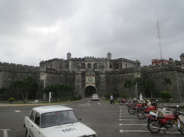
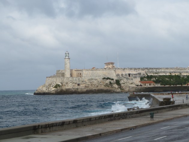
IMG_2100

El Morro Castle


IMG_2132

IMG_2232

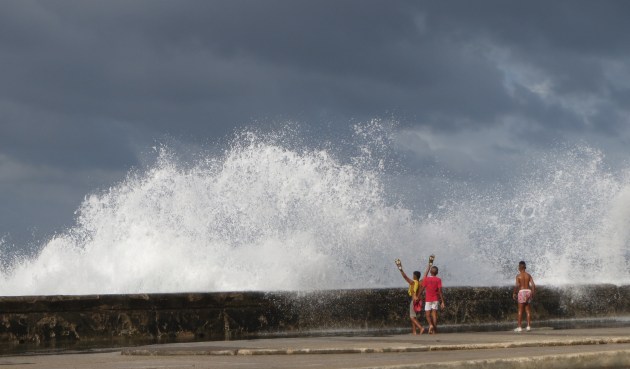
The first few days there were HUGE waves coming over the wall.  Kids LOVED it.!


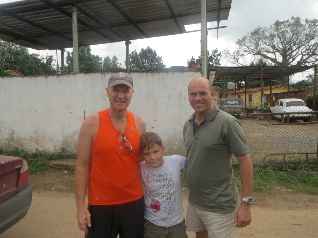
The first thing we did was visit the nearby Hotel Nacional as it was close to our Casa Particular.   We actually bumped into people we’d met the day before at the airport and flew with to Cuba. Was nice to see familiar faces.   They were from Chicago and mentioned that they had just run into Rahm Emanuel, the mayor of Chicago inside the hotel lobby.

The hotel opened its doors in 1930 as it was designed by and for American tourists only and at first no Cubans were allowed to stay there.   The Hotel is a dominant site in Havana and the tours we took passed by it several times. The view from the garden was a 180 degree view of the harbor.

We walked inside and immediately were hit by the history of the area in the lobby. There are still decorations in the Cuban style of 1930s, chandeliers, mahogany furniture and brass fixtures. There are photos of famous visitors around the hallways including Fred Astaire, Frank Sinatra, Gary Cooper and even Walt Disney.

Walking in the grounds of the Hotel Nacional de Cuba we noted more history immediately. Walking into the ground level ‘museum’ we read of the Cuban Missile Crisis, (or as they say in  Havana the October Crisis).  We continued to the underground tunnels that make a circle underneath the hotels lawn and gardens. The tunnels once housed periscopes used by Cuban intelligence in espionage efforts but never nuclear arms.   It was very interesting to walk on these grounds.

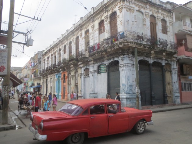
As we continued our explorations, we knew that there were 3 parts to Havana, Old Havana, Centro and Vedado.  Our casa was between the University and Habana Libre, and walked to Old Havana each day (about 1.5 miles). We would walk through Centro as we headed towards Old Havana. There is so much history in the buildings and such, however many are crumbling and falling in on themselves, so it is sad to see that the Cubans have not been able to save more of the historic architecture of the area.  IMG_7034IMG_2171IMG_2099IMG_2300

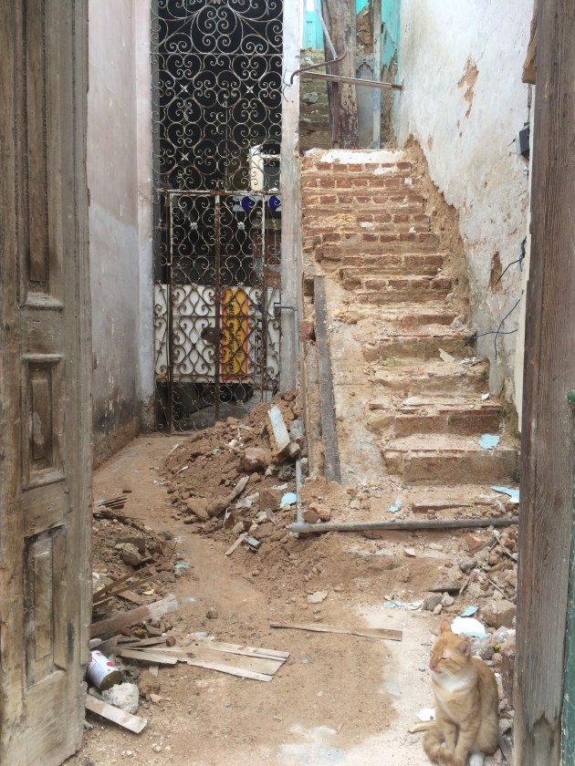
One of our favorite stops was Hamel’s Alley an alley painted by the neighborhood to tell the story of Santera, the Afro-Cuban religion.   Each time we walked through it there we musicians playing music. This was the one spot in town that I felt as if everyone expected money.

We spent our days roaming the Old Havana area full of history and the governmental center of Cuba. We walked through narrow streets and old buildings with balconies full of laundry, plants and people. Many of the home owners offer a room in their home for guests called ‘casa particulars’. They ranged from 20 to 40 CUC’s a night. (when we visited a CUC is 1/1 with the $ but there is a 10% exchange rate).

Some areas of city we enjoyed more than others, I enjoyed the San Fancisco area a lot. The Cubans are trying to renovate many of their plaza’s including Plaza Vieja, Plaza de la Catedral, Plaza de San Francisco and Plaza de Armas as well as the walking only streets: Obispo and Mercaderes both of which we walked on a LOT.

IMG_2138

trying to do some renovations!

We also took the ‘on /off’ open topped bus ride around the town. It was well worth the 5 CUC/pp cost. It took us outside of the downtown center and out to the suburbs of Havana. We were on it for a full 2 hours and then asked for a transfer and eventually rode it back towards our casa.

IMG_7049

Top of the bus!

The bus takes you through the city centre and out to the Miramar (consulate) district, to the Plaza de la Revolucion and back through other suburbs, along the Malecon and into town. We sat on the opened top level of the bus, yes we had broken seats, occasional rain showers and the exhaust fumes were as strong as you might expect, but we enjoyed the ride. JUST know that this is NOT an ‘informative’ tour. There is someone talking occasionally but the sound does not travel to the top level and it is not ‘full of information.’IMG_2193

And we did the ‘touristy’ thing of renting a 1950’s car for a one hour tour, that basically followed the same route as the on off bus, for double the cost!  It was worth it though if for nothing else, the experience.

All in all Havana will leave us with memories but happy and frustrating.  The quote in the Lonely Planet guidebook truly defined our trip:

” Timeworn but magnificent, dilapidated but dignified, fun yet maddeningly frustrating ~ Cuba is a country of indefinable magic.”

We are thrilled we saw it BEFORE it is full of KFC’s/ McDonalds/ and other typical American businesses that are sure to be there in the next few years.
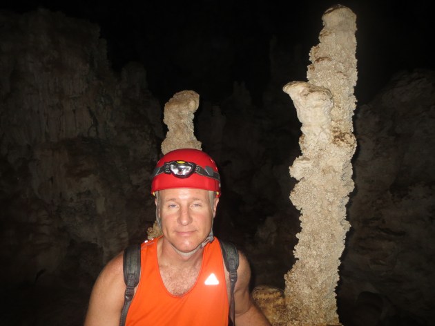


2 Comments »

Totem Park in Klowack, Alaska (Prince of Wales Island)

March 23, 2015

Klawock (originally called Tuxecan) was traditionally a fish camp for the Tlingit that inhabited Prince of Wales Island.   In the late 1870’s ‘white man’ came to the area and built a cannery.   Prince of Wales island is the 4th largest island in the US and I am happy to say I have been to them all. Do you know what they are? (answers below).

indexIMG_4900 IMG_4899


Klawock is one of a few communities on PWI. Craig, Hollis, Hydaburg and Coffman Cove, and are just a few.   Klawock is home to over 800 people! I flew to Klawock on a small plane from Ketchikan, it is about 50 miles.

Culturally Klawock is strong in honoring the Tlingit ancestors.   Yearly there is a celebration for Elizabeth Peratrovich as well as a summer “celebration of the sea’ event. Much of Klowak’s population is Tlingit.

I was honored and touched to be able to walk around the Totem Park one evening. It is the largest grouping of authentic Alaskan totem poles in the world. Many of the totems are identical to the original totems which stood in the area long ago.   Others ARE the originals that were moved here in 2013 when the park was erected.

According to what I read, The first restoration of the Tuxecan totems occurred in the 1930’s when the civilian conservation corp. hired local Klawock natives to create the totem park and preform restoration of the 21 poles that existed at that time.  The poles that were raised in 2013 are the third generation of the poles that were first carved and stood in the old Tlingit village of Tuxecan. 

The Wolf and the Raven clan are proud owners of the totems that were raised in 2013, the newest poles being the:

Killer Whale

Gunyahs “Dog-Eater”

Sun Chief

Kats “Bear Hunter”

Mythological Raven

The raising of these 5 poles completed the second restoration of the 21 Totem poles that are at home on the hill above the first cannery in Alaska

IMG_4928

Here is an example of the petroglyph’s that are found in the area.

.IMG_4927IMG_4930 IMG_4929 IMG_4926 IMG_4925 IMG_4924 IMG_4923 IMG_4922 IMG_4921 IMG_4920 IMG_4918 IMG_4917 IMG_4916

The sawmill and fishing are the big economy in the area and of course any time there are tourists it is a good thing.

(Answer to Island question, #1 Hawaii, #2 Kodiak, #3 Puerto Rico)


2 Comments »

Where in the world is Naknek, Alaska???

IMG_4867

landing about 8:30 a.m. and watching the beautiful sunrise!

IMG_4877

it was a dry cold (BUT very windy by the water)

IMG_4878

boats are everywhere in this area

IMG_4879

town a tad deserted this time of year, but come July I bet it is packed.

IMG_4880

looking out over Bristol Bay

IMG_4886

since it is salt water it does not freeze totally but since there is some fresh water feeding into the bay the fresh water will freeze and break up as the tide goes in and out.

IMG_4892

I heard they are putting a new museum in this building!

IMG_4896

in front of the famous Naknek River

IMG_4890 IMG_4891 IMG_4893 IMG_4894 IMG_4898

March 13 and 14

Naknek, Alaska is the home to Bristol Bay School district, I was thrilled to be able to go there and work with the board this spring.  There are about 550 people that live in Naknek however they are also attached by road to King Salmon.  I flew into the King Salmon airport.

This land is the land of the Yupik and Athabaskan Alaska Natives. The community was known as Naugeik until the Russians came to the area in the 1800’s and changed the spelling to Naknek.

The area is known worldwide for it’s fishing! There was a cannery opened there in 1890 and there were 12 canneries at the height of business.   There are currently 6 processing plants left in Naknek.

Noteworthy tidbit: About 70% of the world’s sockeye is caught here, mostly in July!

The Naknek River runs into the Kvichak Bay arm.  I got to go and stand on the edge of the bay, the cold whistling winds whipped through the air making my eyes water a bit!

For me and my job I found another fascinating fact; the superintendent and 4 out of 5 board members were born/ raised in the area. Can’t say that too often any more!naknek_map

Leave a comment »

Cordova Alaska, 2012 Record snow, 2015 NO snow!

Feb. 3/4, 2015

I have visited Cordova a lot over the last few years, but it is stunning how different a few years can make.  3 years ago they were buried in snow and today there is NONE… the white stuff on the ground is frost. Here is the post from 2012 and some photos from today!  They made national news in 2012 because of the snow and the National Guard was called in to help shovel the snow off of roofs.

https://timistravels.wordpress.com/2012/01/16/cordova-alaska-during-snowpocyolypse-2012/

IMG_2960 IMG_2958

Much like my last blog I am here help the board hire a superintendent, this is the information they put in their ad.  Enjoy

“Cordova is located at the southeastern end of Prince William Sound in the Gulf of Alaska. The community was built on Orca Inlet, at the base of Eyak Mountain. It lies 52 air miles southeast of Valdez and 150 miles southeast of Anchorage.  Winter temperatures are mild with average snowfall of 80 inches though this winter they have made national news with their record snowfall! Cordova has become home to those that enjoy the natural beauty of the area and for those that love the out-of-doors. Fishing, hiking, hunting, and most outdoor activities make Cordova’s unique surroundings desirable for many. Summer temperatures average from 50 to 63. Cordova is accessed by plane or boat. It is linked directly to the North Pacific Ocean shipping lanes through the Gulf of Alaska. It receives year-round barge services and State Ferry service.


The area has historically been home to the Alutiiq, with the addition of migrating Athabascan and Tlingit natives. Orca Inlet was originally named “Puerto Cordova” by Don Salvador Fidalgo in 1790. The town of Cordova was named in 1906 and the City was formed in 1909. Cordova became the railroad terminus and ocean shipping port for copper ore from the Kennecott Mine up the Copper River.


Cordova supports a large fishing fleet for Prince William Sound and several fish processing plants. Over 300 of the 2100 year-round residents hold commercial fishing permits, and nearly half of all households have someone working in commercial harvesting or processing. In the summers, Cordova doubles in population as fishermen and others flock to town for involvement with the fishing industry. Copper River red salmon, pink salmon, herring, halibut, bottom fish and other fisheries are harvested. The largest employers are Trident Processors, Cordova School District, Cordova Hospital, the City, and the Department of Transportation. The U.S. Forest Service and the U.S. Coast Guard maintain personnel in Cordova.”

Leave a comment »

Petersburg, Alaska’s “Little Norway”

Jan. 28-29, 2015

This will be the first of 3 visits to Petersburg, Alaska for the year 2015.  I am assisting them as they hire a new superintendent of schools.  This is a short blog which highlights the community of Petersburg in the words outlined in job description for the superintendency!  map

Petersburg is an island home to approximately 3,000 residents, where small town life influences the social and work environments. The town, located on the north end of Mitkof Island, is nestled among the forested islands and mountains of Southeast Alaska’s Inside Passage.  Nearby Frederick Sound is a summer feeding grounds for hundreds of humpback whales. The Stikine-LeConte Wilderness Area, with its beautiful LeConte Glacier calving off tons of bright blue icebergs, is a short boat ride away.

Mitkof Island was once home to Tlingit fish camps. Present-day Petersburg was settled in the 1890’s by Norwegian fishermen and families. To this day, Petersburg reflects the cultural and artistic influences of its early roots.

Petersburg is surrounded by the Tongass National Forest, the world’s largest temperate rainforest. In 2014 Petersburg had record rainfall receiving over 115”, though this rain helps the lush environment. Its maritime climate means that summers are cool and winters are mild. Average precipitation is approximately 110 inches, which mostly arrives in the form of rain. Recreational opportunities abound in this area of natural beauty including boating, hiking, camping, fishing, hunting, sea kayaking and whale-watching.

Homeport to one of the most productive commercial fishing fleets in the state, Petersburg has three busy fish processing plants operating in the summer. Both the Forest Service and Coast Guard have a presence in Petersburg helping add to the diversity of the community.

There is twice-daily Alaska Airlines jet service to either Juneau/Anchorage or Seattle, and the Alaska’s Marine Highway System ferries dock in Petersburg. Excellent medical services include a hospital with a clinic and long-term care unit, four doctors, two dentists and a full-service pharmacy. Attractive senior citizen housing is also available. Many families are second and third generation residents who have grown up in Petersburg and graduated from the schools their own children and grandchildren now attend. The stability of the community and educational environment contributes to a longstanding reputation for high student expectations and achievement.photo (14)

Leave a comment »

Guided Trek on Mendenhall Icefield with local company, Northstar Trekking

July 22, 2014

What better way to celebrate our 14th anniversary than to go on a helicopter ride and trek on Mendenhall Glacier Harry and I once again took advantage of a certificate we had gotten during a fundraiser earlier this year. We have gone with Northstar Trekking 3 other times and each time it is a new adventure.

After realizing we were locals AND had gone with NST before our pilot Tracey wanted to know ‘what we wanted to see’, after telling her where we’d been before she headed N almost directly over our house then curved over towards the icefield.

IMG_1232

flying over Herbert Glacier. We ride our bicycles to the face of this a few times a year

IMG_1234

Eagle Glacier is receding quite rapidly.

IMG_1245

looking into Canada, this is probably Camp Peak

IMG_1241

some of the smaller glaciers in the icefield

IMG_1242

the pointed tips were never covered by glaciers, but the more rounded peaks were made rounded by glacier ice smoothing them out.

IMG_1250

other than being on the glacier this is my favorite picture of the day. This is Snow Tower Peaks

First we flew over Mt. Stroller White towards Herbert Glacier and continued N to Eagle Glacier. The amazing part of the flight was that we could begin to see Canadian Peeks. Along the way we also saw so many peaks that it is hard to describe let alone name them all, though Snow Tower Peaks were stunning.

IMG_1256

swinging around to head down to our trekking spot

IMG_1267

we’ve landed and I want to point out the people in this picture, it gives perspective of how large the glacier is.

The Juneau Icefield is the 5th largest icefield in America covering 1500 square miles. It is about 100 miles deep and 50 miles east to west. This icefield is about 3000 years old, so indeed there are pyramids older than this ice! Think about the icefield as one big lake with many rivers flowing out of the lake, these rivers are the glaciers. There are approximately 40 significant glaciers flowing off this field and about 100 smaller ones.

IMG_1278

in front of a ‘cave’ that was not here last week and will probably be gone in a week..

Yes Mendenhall melting and yes it is moving. It takes about 10 feet of snow to create one foot of ice, so each winter a layer is established on the icefield, but it is not growing as fast as it is melting. I have seen significant movement in the glacier in the 19 years I have lived here, it is the sad truth.

IMG_1293

filling water bottle to drink some of the clear, cold water flowing through the glacier.

IMG_1326

just as we were to depart, the tent is there for staff to store things in or to get out of the elements on not so nice days.

IMG_1318

These crevasses are about 150 feed down, you don’t want to fall.

IMG_1306

again for perceptive, this has tent and helicopter as well as people.

This is the same glacier that we were able to hike in the ice caves earlier this year, sadly they have started to collapse and it is very unsafe to return now.  http//timistravels.wordpress.com/2014/03/08/mendenhall-glacier-ice-caves-and-some-northern-lights/


Leave a comment »

Small town Charm in Seldovia, Alaska

IMG_1172

do you see the face of a bear in these rocks? I do and I love it!!! taken from ferry ride.

IMG_1161

wish I would have caught this, but I just decided to stand by it! It’s about a 90# Halibut.

IMG_1144

locals call this camel rock, I can see why!


July 18, 2014

A day in Seldovia, Alaska

I, for one love quaint little towns that embrace what Alaska is all about and Seldovia is just that kind of town. We were in Homer for work but had the opportunity to take the ferry ride over to Seldovia and spend the afternoon there.

IMG_1087

view from the ferry as we left Homer


IMG_1106

we saw whales breaching during the ferry ride. I almost caught the ‘fluke’ (whales tail)

IMG_1095

sea otters are everywhere in the waters in this area

IMG_1125

little sea otter playing in the harbor


IMG_1120

arriving to Seldovia, can you tell it’s a fishing community


IMG_1132

such beautiful flowers welcoming the ferry


It is a quieter community, as it is not on the road system; you have to try to get there! The community is far removed from the hustle and bustle of life in bigger communities in Alaska. It’s a town full of small town charm including Christmas Light contest, an annual chainsaw competition (with many of the carvings decorating town), and a solstice music festival just to name a few.IMG_1124IMG_1133

berries

a bowl of salmon berries is a summer treat!

We were hosted by a local for lunch and had yummy fresh salmon and halibut! What a treat. We then visited the Susan Early School on our way to the Otterbahn Hike and visit to the beach. I collected a lot of beach glass, (which I love) as well as filling 2 bags with salmon berries!IMG_1138IMG_1134

seldovia map

just in case you were wondering where it is on the map of Alaska

I’ve read a trip advisor reviews where people complained that there was “nothing to do” but I disagree, it is a delightful step into a beautiful community that isn’t full of tourist shops and billboards, it is a quaint Alaska community full of kindness and great old-fashioned hospitality.

Leave a comment »

Mendenhall Glacier Ice Caves (and some Northern Lights)

March 1, 2014

Almost every Feb. or March Juneau has a cold snap where Mendenhall Lake freezes enough that individuals can get out on the lake to cross country ski, or hike etc.  Typically during that time it is also quite sunny and the rain or snow subsides for a few weeks.

These explorations around Mendenhall Glacier are typically astounding, and the photos that come out of the visits make our Christmas Card each year, it is truly part of what makes Juneau such an incredible place to live, these things are in our back yard.

This year the glacial caves are getting a lot of attention from National news outlets but here are a few of my photos from the weekend of March 1 and 2, 2014.  I went on my own Sat. but did not enter the caves.  I made Harry get up early with me on Sunday and get out there when 1) there were not many people there at all and 2) I felt a little more safe with it being colder in the morning.  There is danger doing this but it was worth the risk!

The few Northern Light pictures are NOT taken by me, rather a friend of a friend.  Thought you may enjoy seeing them!

IMG_2496

out near the face of glacier

IMG_0735

harry inside the cave, yes, real colors, not altered at all

IMG_0737

me enjoying being silly

IMG_0761

over my right shoulder is a ice column in the cave, facinating

IMG_0768

just outside the cave with the peaks above my head being higher up on glacier.

IMG_0789

harry at the face being silly himself

IMG_0743

while in the cave we are looking up out of these holes…

IMG_0804

this ice cave I would not venture into, there were sounds coming out of it and that triangular piece above Harry’s left arm looks to scary to me.

IMG_0690

I hiked out to face on Sat. by myself, but did not venture into the caves

IMG_0719

just as you enter the cave

IMG_0732

that ice column that is in the middle of the cave, not quite sure how it formed, possibly a water drip that grew???

IMG_0782

the natural heart cut out I found hiking around the face of glacier

IMG_0785

out near face so much BLUE

IMG_0764

not touched up at all, the colors were simply incredible, almost looks fake doesn’t it?

Dylans house aurora 1

during this same time period we also get great Northern Lights. I did NOT take this photo rather it was taken by David Reed, a friend of a friend of a friend.

North Douglas

again by David Reed, this is taken out on North Douglas. the lights along the bottom are car lights. the light over the hilltop to the right is near our home!

2 Comments »